Flight plan - KA-20240903a

Contents

Flight plan - KA-20240903a#

in_cloud curtain insitu_aerosol

Crew#

The flight is planned to take off at 2024-09-03 17:00:00+00:00.

Job

Name

PI

Tim Carlsen

Instrument operator

Sorin Ghemulet

Instrument operator

Alex Vlad

Flight plan#

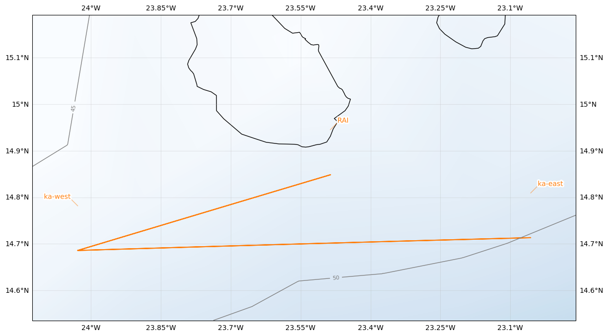
Leg 1: RAI -> ka-west (arrive @FL180 at 18:00 UTC | 17:00 LT) - Note: Holding pattern until 18:25 UTC

Leg 2 (Start 18:25 UTC): ka-west -> ka-east (in-cloud at cloud top, ~FL150), 180 kt - Note: Communication with HALO (D-ADLR) via 123.45 MHz to coordinate start of common leg

Leg 3: ka_east -> ka_west (in-cloud at cloud top)

Leg 4: ka_west -> RAI

Hide code cell source
from orcestra.flightplan import sal, bco, LatLon, IntoCircle, path_preview, plot_cwv
from datetime import datetime
import intake
import easygems.healpix as egh

cat = intake.open_catalog("https://tcodata.mpimet.mpg.de/internal.yaml")

# Define dates for forecast initialization and flight

issued_time = datetime(2024, 9, 2, 0, 0, 0)
issued_time_str = issued_time.strftime('%Y-%m-%d')

flight_time = datetime(2024, 9, 3, 12, 0, 0)
flight_time_str = flight_time.strftime('%Y-%m-%d')
flight_index = f"KA-{flight_time.strftime('%Y%m%d')}a"

print("Initalization date of IFS forecast: " + issued_time_str + "\nFlight date: " + flight_time_str + "\nFlight index: " + flight_index)

airport = LatLon(lat=14.945, lon=-23.4863889, label='RAI')

ka_west = LatLon(lat=14.78167, lon= -24.028371, label='ka-west')
ka_east = LatLon(lat=14.809248, lon=-23.056479, label='ka-east')

leg_out = [
     airport,
     ka_west
]

leg_halo = [
      ka_west,
      ka_east,
      ka_west
]

leg_home = [
     ka_west,
     airport
]

path = leg_out + leg_halo + leg_home 

cat = intake.open_catalog("https://tcodata.mpimet.mpg.de/internal.yaml")
ds = cat.HIFS(datetime=issued_time).to_dask().pipe(egh.attach_coords)
cwv_flight_time = ds["tcwv"].sel(time=flight_time, method = "nearest")

ax = path_preview(path)

ax.scatter(-23.31, 14.41, c='red', marker='o', s=200, ec = 'r', alpha = 0.3)
ax.scatter(-22.34, 14.41, c='red', marker='o', s=200, ec = 'r', alpha = 0.3)
ax.scatter(-21.760275, 14.839639, c='red', marker='o', s=200, ec = 'r', alpha = 0.3)

ka_west_alt = LatLon(lat=14.41, lon= -23.31, label='ka-west-alt')
ka_east_alt = LatLon(lat=14.41, lon=-22.34, label='ka-east-alt')
atr_in = LatLon(lat=14.839639, lon=-21.760275, label='atr-in')

plot_cwv(cwv_flight_time)
Initalization date of IFS forecast: 2024-09-02
Flight date: 2024-09-03
Flight index: KA-20240903a
../_images/639151cd47031472d205c56974d72be2ecf2268049a76e3f4a621ff68a32646a.png
Hide code cell source
import pandas as pd
from dataclasses import asdict

pd.DataFrame.from_records(map(asdict, [airport, ka_west, ka_east, airport, ka_west_alt, ka_east_alt, atr_in])).set_index("label")
lat lon fl time note
label
RAI 14.945000 -23.486389 None None None
ka-west 14.781670 -24.028371 None None None
ka-east 14.809248 -23.056479 None None None
RAI 14.945000 -23.486389 None None None
ka-west-alt 14.410000 -23.310000 None None None
ka-east-alt 14.410000 -22.340000 None None None
atr-in 14.839639 -21.760275 None None None