

Flight plan - KA-20240831a#
ec_under ec_track in_cloud insitu_aerosolCrew#
The flight is planned to take off at 2024-08-31 14:00:00+00:00.
Job |
Name |
|---|---|
PI |
Robert Oscar David |
Instrument operator |
Sorin Ghemulet |
Instrument operator |
Marius Corbu |
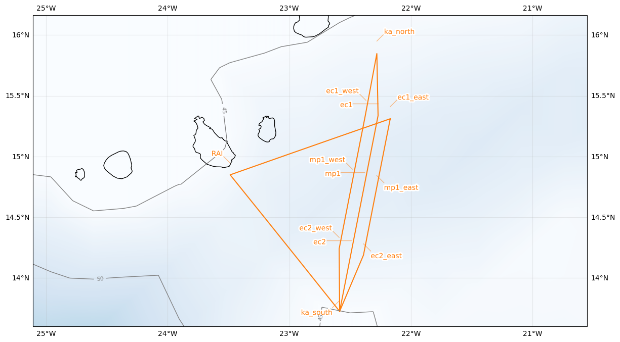
Flight plan#
Leg 1: RAI -> ka_south (arrive @FL065 at 14:45 UTC | 13:45 LT) - Note: Holding pattern until 15:07 UTC
Leg 2: ka_south -> ec2 (cloud top, ~FL065-FL030), 180 kt - Note: Communication with ATR (F-HMTO) via 123.45 MHz to coordinate start of common leg and cloud information
Leg 3 (Start 15:25 UTC): ec2 -> ec1 (via mp1) - porpoising between cloud base and cloud top - 180 kt - Note: Be at mp1 at 15:37 UTC | 14:37 LT for satellite overpass
Leg 4: ec1 -> ka_north (to de-conflict with F-HMTO)
Leg 5: ka_north -> ec1_west (coordinate with F-HMTO when arrival at ec1_west)
Leg 6: ec1_west -> ec2_west (via mp1_west) - estimated FL055 (1000 ft below F-HMTO to de-conflict)
Leg 7: ec2_west -> ka_south (to de-conflict with F-HMTO)
Leg 8: ka_south -> ec2_east (coordinate with F-HMTO when arrival at ec2_east)
Leg 9: ec2_east -> ec1_east (via mp1_east) - estimated FL055 (1000 ft above F-HMTO to de-conflict)
Leg 10: ec1_east -> RAI (de-conflict with F-HMTO for corridor out)
Initalization date of IFS forecast: 2024-08-30
Flight date: 2024-08-31
Flight index: KA-20240831a
| lat | lon | fl | time | note | |
|---|---|---|---|---|---|
| label | |||||
| RAI | 14.945000 | -23.486389 | None | None | None |
| ka_south | 13.813437 | -22.586137 | None | None | None |
| ec2 | 14.305833 | -22.490000 | None | None | None |
| mp1 | 14.868333 | -22.380833 | None | None | None |
| ec1 | 15.435833 | -22.270000 | None | None | None |
| ka_north | 15.950000 | -22.280000 | None | None | None |
| ec1_west | 15.462000 | -22.370000 | None | None | None |
| mp1_west | 14.894500 | -22.480833 | None | None | None |
| ec2_west | 14.332000 | -22.590000 | None | None | None |
| ka_south | 13.813437 | -22.586137 | None | None | None |
| ec2_east | 14.279667 | -22.390000 | None | None | None |
| mp1_east | 14.842167 | -22.280833 | None | None | None |
| ec1_east | 15.409667 | -22.170000 | None | None | None |
| RAI | 14.945000 | -23.486389 | None | None | None |