Flight plan - KA-20240829a

Contents

Flight plan - KA-20240829a#

ec_under ec_track in_cloud spiral_mindelo insitu_aerosol

Crew#

The flight is planned to take off at 2024-08-29 14:20:00+00:00.

Job

Name

PI

Tim Carlsen

Instrument operator

Sorin Ghemulet

Instrument operator

Alex Vlad

Flight plan#

Arrive @FL050 at WP1 at 15:00 UTC (14:00 LT)

Holding pattern at WP1 until 15:28 UTC (assessing cloud situation) Note: Communication with ATR (F-HMTO) via 123.45 MHz to get cloud information

Start 15:28 UTC: WP1 -> WP3 (via WP 2) - around FL030-FL050 - 140 kt (~40min) - in-cloud if possible Note: Be at WP2 at 15:48 UTC | 14:48 LT for satellite overpass and ATR meet

WP3 -> WP4, ascend to FL150

Descent as race-track pattern with one straight leg between WP4 and WP5 from FL150 down to FL040 Notes: - if possible with VXE airport Mindelo - WP5: 16.91 N | 25W - 1000 ft/min, right turn - Alternate WP4 (16.99N | 24.83W): in case WP4 not possible

Ascent as race track pattern with one straight leg between WP4 and WP5 from FL040 up to FL150 Notes: - if possible with VXE airport Mindelo - WP5: 16.91 N | 25W - 1000 ft/min, right turn - Alternate WP4 (16.99N | 24.83W): in case WP4 not possible

Return home to RAI.

Hide code cell source
from orcestra.flightplan import sal, bco, LatLon, IntoCircle, path_preview, plot_cwv
from datetime import datetime
import intake
import easygems.healpix as egh

cat = intake.open_catalog("https://tcodata.mpimet.mpg.de/internal.yaml")

# Define dates for forecast initialization and flight

issued_time = datetime(2024, 8, 28, 0, 0, 0)
issued_time_str = issued_time.strftime('%Y-%m-%d')

flight_time = datetime(2024, 8, 29, 12, 0, 0)
flight_time_str = flight_time.strftime('%Y-%m-%d')
flight_index = f"KA-{flight_time.strftime('%Y%m%d')}a"

print("Initalization date of IFS forecast: " + issued_time_str + "\nFlight date: " + flight_time_str + "\nFlight index: " + flight_index)

airport = LatLon(lat=14.945, lon=-23.4863889, label='RAI')

ec_south = LatLon(lat=14.368185, lon=-25.148931, label='ec_south')
ec_meet = LatLon(lat=15.22805556, lon=-24.9691667, label='EC_ATR_meet')
ec_north = LatLon(lat=16.116939, lon=-24.807302, label='ec_north')
mindelo = LatLon(lat=16.877772, lon=-24.995374, label='mindelo')

leg_out = [
     airport,
     ec_south
]

leg_calval = [
      ec_south,
      ec_meet,
      ec_north
]

leg_transfer = [
      ec_north,
      mindelo
]

leg_home = [
     mindelo,
     airport
]

path = leg_out + leg_calval + leg_transfer + leg_home 

cat = intake.open_catalog("https://tcodata.mpimet.mpg.de/internal.yaml")
ds = cat.HIFS(datetime=issued_time).to_dask().pipe(egh.attach_coords)
cwv_flight_time = ds["tcwv"].sel(time=flight_time, method = "nearest")

ax = path_preview(path)

ax.scatter(-24.995374, 16.877772, c='red', marker='o', s=200, ec = 'r', alpha = 0.3)

plot_cwv(cwv_flight_time)
Initalization date of IFS forecast: 2024-08-28
Flight date: 2024-08-29
Flight index: KA-20240829a
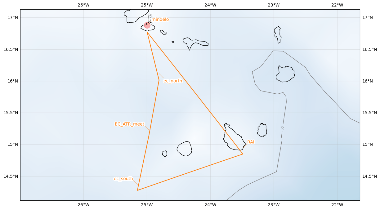
../_images/1310551b7b7a8c21faf35d35e98c788fa42c12a923314c6146e090cd4d2b7576.png
Hide code cell source
import pandas as pd
from dataclasses import asdict

pd.DataFrame.from_records(map(asdict, [airport, ec_south, ec_meet, ec_north, mindelo, airport])).set_index("label")
lat lon fl time note
label
RAI 14.945000 -23.486389 None None None
ec_south 14.368185 -25.148931 None None None
EC_ATR_meet 15.228056 -24.969167 None None None
ec_north 16.116939 -24.807302 None None None
mindelo 16.877772 -24.995374 None None None
RAI 14.945000 -23.486389 None None None