

Flight plan - KA-20240827a#
in_cloud spiral meteorCrew#
The flight is planned to take off at 2024-08-27 15:30:00+00:00.
Job |
Name |
|---|---|
PI |
Robert Oscar David |
Instrument operator |
Sorin Ghemulet |
Instrument operator |
Marius Corbu |
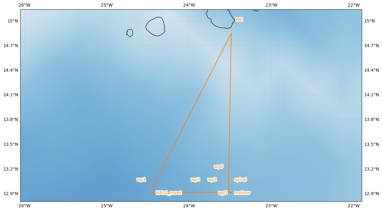
Flight plan#
Arrive @FL200 at 16:09 UTC at WP1 - holding pattern until 16:29 UTC.
At 16:29 UTC: WP1 -> WP2 at cloud top (max FL280, ~20min). HALO passes over us at 16:39 UTC at FL450 at HALO_meet (13.0 N, -24.04 W). Holding pattern at WP2 for 5 min to allow for westward scan direction of SEA-POL radar on RV Meteor.
16:55 UTC: WP2 -> WP3 -> WP2 -> …: Descent with 1000 ft/min from cloud top down to FL010.
Arrive at WP4 (RV Meteor) at FL010 (safe altitude from SEA-POL radar).
Spiral ascent from FL010 to cloud top (max. FL280). Ascent as race-track pattern with one straight leg between WP5 and WP6: - WP5: -23.4785 W, 13.0 N - WP6: -23.5215 W, 13.0 N
Return home to RAI: descent through potential clouds on the way home.
Initalization date of IFS forecast: 2024-08-27
Flight date: 2024-08-27
Flight index: KA-20240827a
| lat | lon | fl | time | note | |
|---|---|---|---|---|---|
| label | |||||
| RAI | 14.945 | -23.486389 | None | None | None |
| wp1 | 13.000 | -24.470000 | None | None | None |
| HALO_meet | 13.000 | -24.040000 | None | None | None |
| wp2 | 13.000 | -23.610000 | None | None | None |
| wp3 | 13.000 | -23.813500 | None | None | None |
| meteor | 13.000 | -23.500000 | None | None | None |
| wp5 | 13.000 | -23.478500 | None | None | None |
| wp6 | 13.000 | -23.521500 | None | None | None |
| RAI | 14.945 | -23.486389 | None | None | None |