Flight plan - HALO-20240907a

Contents

Flight plan - HALO-20240907a#

ec_under ec_track c_north c_mid c_south

Crew#

The flight is planned to take off at 2024-09-07 12:51:06+00:00.

Job

Name

PI

Bjorn Stevens

WALES

Georgios Dekoutsidis

HAMP

Clara Bayley

Dropsondes

Helene Glöckner

Smart/VELOX

Michael Schäfer

SpecMACS

Anja Stallmach

Flight Documentation

Daniel Rowe

Ground contact

Chavez Pope

Flight plan#

Hide code cell source
from dataclasses import asdict
from datetime import datetime
import orcestra.sat
from orcestra.flightplan import bco, sal, mindelo, point_on_track, LatLon, IntoCircle, FlightPlan

# Some fixed coordinates

lon_min, lon_max, lat_min, lat_max = -65, -5, -5, 25

airport = bco

radius = 72e3*1.852

# Define dates for flight

flight_time   = datetime(2024, 9, 7, 12, 0, 0)
flight_index = f"HALO-{flight_time.strftime('%Y%m%d')}a"

# Load satellite tracks 

ec_fcst_time  = "2024-09-06"
ec_track = orcestra.sat.SattrackLoader("EARTHCARE", ec_fcst_time, kind="PRE",roi="BARBADOS") \
    .get_track_for_day(f"{flight_time:%Y-%m-%d}")\
    .sel(time=slice(f"{flight_time:%Y-%m-%d} 14:00", None))

# Create elements of track

c_south  = point_on_track(ec_track,lat=  7.00).assign(label = "c_south")
c_mid    = point_on_track(ec_track,lat= 10.25).assign(label = "c_mid")
c_north  = point_on_track(ec_track,lat= 13.50).assign(label = "c_north")

c_wait   = c_south.towards(c_mid,distance=radius*0.75).assign(label = "c_wait")
join     = c_south.towards(c_mid,distance=radius).assign(label = "join")
c_out    = c_north.towards(c_mid,distance=radius).assign(label = "c_out")
ec_north = point_on_track(ec_track,lat= 15.00).assign(label = "ec_north") 
xlat     = c_south.towards(c_mid,distance=-radius).lat
ec_south = point_on_track(ec_track,lat=  xlat).assign(label = "ec_south")
ec_mid   = ec_north.towards(ec_south).assign(label = "ec_mid")
ec_turn  = ec_mid.towards(ec_south,fraction=2/3.).assign(label = "ec_turn")

xlat     = c_mid.towards(c_north,fraction=1/6).lat
ec_under = point_on_track(ec_track, lat=xlat, with_time=True).assign(label = "ec_under", note = "meet EarthCARE")

# Additional Waypoints

extra_waypoints = []

# Define Flight Paths

waypoints = [
    airport.assign(fl=0),
    join.assign(fl=410),
    IntoCircle(c_wait.assign(fl=410), radius/4,  360),   
    IntoCircle(c_south.assign(fl=410), radius,360),   
    join.assign(fl=410),
    IntoCircle(c_mid.assign(fl=430), radius, -360,enter=-90), 
    c_mid.assign(fl=450),
    ec_under.assign(fl=450),
    c_out.assign(fl=450),
    IntoCircle(c_north.assign(fl=450), radius, -360), 
    airport.assign(fl=0),
]

# Crew

crew = {
    'Mission PI': 'Bjorn Stevens',
    'DropSondes': 'Helene Glöckner',
    'HAMP': 'Clara Bayley',
    'SMART/VELOX': 'Michael Schäfer',
    'SpecMACS': 'Anja Stallmach',
    'WALES' : 'Georgios Dekoutsidis',
    'Flight Documentation': 'Daniel Rowe',
    'Ground Support': 'Chavez Pope'
}

# Plan

plan = FlightPlan(waypoints, flight_index, extra_waypoints=extra_waypoints, crew=crew)
print(f"Flight index: {plan.flight_id}")
print(f"Take-off: {plan.takeoff_time:%H:%M %Z}\nLanding:  {plan.landing_time:%H:%M %Z}\n")
/home/runner/miniconda3/envs/orcestra_book/lib/python3.12/site-packages/orcestra/sat.py:195: UserWarning: You are using an old forecast (issued on 2024-09-06) for EARTHCARE on 2024-09-07! The newest forecast issued so far was issued on 2024-09-07. It's a PRE forecast.
  warnings.warn(
/home/runner/miniconda3/envs/orcestra_book/lib/python3.12/site-packages/orcestra/flightplan.py:214: FutureWarning: The aircraft attribute of this FlightPlan is not set, but it's required for aircraft performance calculations. Currently, the code will proceed using the default aircraft performance, but the code may break in future.
  warn(
Flight index: HALO-20240907a
Take-off: 12:51 UTC
Landing:  20:16 UTC
Hide code cell source
import matplotlib.pyplot as plt
import cartopy.crs as ccrs
import easygems.healpix as egh
import intake
from orcestra.flightplan import plot_cwv, plot_path

forecast_overlay = True

plt.figure(figsize = (14, 8))
ax = plt.axes(projection=ccrs.PlateCarree())
ax.set_extent([lon_min, lon_max, lat_min, lat_max], crs=ccrs.PlateCarree())
ax.coastlines(alpha=1.0)
ax.gridlines(draw_labels=True, dms=True, x_inline=False, y_inline=False, alpha = 0.25)

if (forecast_overlay):
    ifs_fcst_time = datetime(2024, 9, 4, 0, 0, 0)
    ds = intake.open_catalog("https://tcodata.mpimet.mpg.de/internal.yaml").HIFS(datetime = ifs_fcst_time).to_dask().pipe(egh.attach_coords)
    cwv_flight_time = ds["tcwv"].sel(time=flight_time, method = "nearest")
    plot_cwv(cwv_flight_time, levels = [50.0, 60.0], ax=ax)
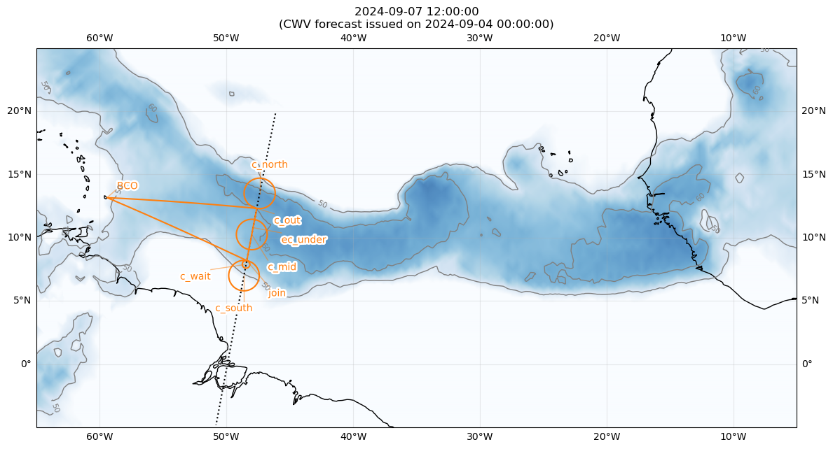
    plt.title(f"{flight_time}\n(CWV forecast issued on {ifs_fcst_time})")

plt.plot(ec_track.lon, ec_track.lat, c='k', ls='dotted')
plot_path(plan, ax, color="C1")

if (False):
    natal   = LatLon(-5.795,-35.209439, label = "natal")
    airways = [natal,sal]
    plot_path(airways, ax, color="purple")
../_images/a94a806f7dcb30b30e3856da939cf41fd892b440e9257d6849a5086017397630.png
Hide code cell source
from orcestra.flightplan import vertical_preview

vertical_preview(waypoints)
../_images/e20d4967150315347ef12fcc613017e74161033a01e7e8735bb6e6f5e81eb1a6.png
Hide code cell source
plan.show_details()
plan.export()
Detailed Overview:
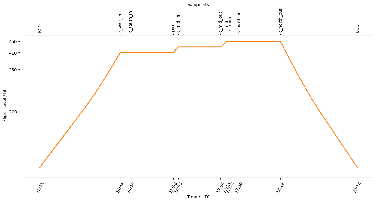
              BCO          N13 09.76, W059 25.72, FL000, 12:51:31 UTC, 
to            join         N08 11.10, W048 23.92, FL410, 14:44:11 UTC, 
circle around c_wait       N07 53.33, W048 27.27, FL410, 14:44:11 UTC - 14:59:04 UTC, radius: 18 nm, 360° CW, enter from north
circle around c_south      N07 00.00, W048 37.29, FL410, 14:59:04 UTC - 15:58:38 UTC, radius: 72 nm, 360° CW, enter from north
to            join         N08 11.10, W048 23.92, FL410, 15:58:38 UTC, 
circle around c_mid        N10 15.00, W048 00.42, FL430, 16:05:39 UTC - 17:04:40 UTC, radius: 72 nm, 360° CCW, enter from south
to            c_mid        N10 15.00, W048 00.42, FL450, 17:14:01 UTC, 
to            ec_under     N10 47.51, W047 54.23, FL450, 17:18:17 UTC, meet EarthCARE
to            c_out        N12 18.95, W047 36.77, FL450, 17:30:16 UTC, 
circle around c_north      N13 30.00, W047 23.04, FL450, 17:30:16 UTC - 18:28:49 UTC, radius: 72 nm, 360° CCW, enter from south
to            BCO          N13 09.76, W059 25.72, FL000, 20:16:28 UTC, 
/home/runner/miniconda3/envs/orcestra_book/lib/python3.12/site-packages/orcestra/flightplan.py:214: FutureWarning: The aircraft attribute of this FlightPlan is not set, but it's required for aircraft performance calculations. Currently, the code will proceed using the default aircraft performance, but the code may break in future.
  warn(