Flight plan - ATR-20240822a

Contents

Flight plan - ATR-20240822a#

ec_under c_atr

Flight plan#

  • The flight is planned to take off at 2024-08-22 13:15:00+00:00 UTC and land at 2024-08-22 16:45:00+00:00 UTC.

  • HALO is expected to fly a circle around the ATR at about 16:10 UTC (subject to change)

  • EarthCare colocation with HALO at 15:41 UTC.

Hide code cell source
from orcestra.flightplan import sal, bco, LatLon, IntoCircle, path_preview, plot_cwv
from datetime import datetime
import intake

cat = intake.open_catalog("https://tcodata.mpimet.mpg.de/internal.yaml")

date_time = datetime(2024, 8, 20, 12, 0, 0)
date_time_str = date_time.strftime('%Y-%m-%d')
flight_time = datetime(2024, 8, 22, 12, 0, 0)

radius = 60e3 # units: km
circle_atr = LatLon(lat=14.180, lon=-23.110, label="circle_atr")
halo_circle = IntoCircle(circle_atr, radius, 360)

airport = sal
wp1 = LatLon(lat=16.204, lon=-22.480, label='wp1')
wp2 = LatLon(lat=13.891, lon=-23.166, label='wp2')
ec_meet = LatLon(lat=14.336, lon=-23.080, label='EC meeting pt')
wp3 = LatLon(lat=14.780, lon=-22.993, label='wp3')
wp4 = LatLon(lat=13.903, lon=-23.258, label='wp4')
wp5 = LatLon(lat=15.347, lon=-23.323, label='wp5')

path = [airport, wp1, wp2, ec_meet, wp3, wp4, wp5, airport]

ds = cat.HIFS(refdate=date_time_str, reftime=date_time.hour).to_dask()
cwv_flight_time = ds["tcwv"].sel(time=flight_time, method = "nearest")

ax = path_preview(path)
path_preview([circle_atr.course(0, radius), halo_circle], ax=ax)  # HACK: Add HALO circle
ax.scatter(circle_atr.lon, circle_atr.lat, color="tab:orange")
ax.text(circle_atr.lon+0.05, circle_atr.lat-0.20, color="tab:orange", s='HALO_Circle', bbox=dict(facecolor='white',edgecolor='white', boxstyle='round,pad=0.1'))
ax.set_extent([-24, -21, 13.3, 17])

plot_cwv(cwv_flight_time)
../_images/1fa2c2f7860767eb371eab2a70480e5a791afbc630ea2c9ed902a4f9d5767b5e.png
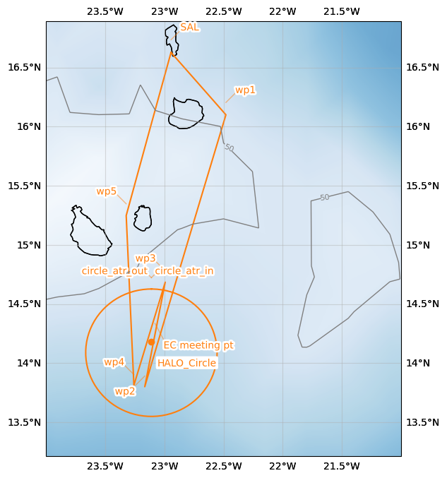
  • SAFIRE Flight Plan submitted to Air Traffic Control (ATC)

Page 1

Hide code cell source
import pandas as pd
from dataclasses import asdict

pd.DataFrame.from_records(map(asdict, path+[circle_atr])).set_index("label")
lat lon fl time note
label
SAL 16.734488 -22.943974 0.0 None None
wp1 16.204000 -22.480000 NaN None None
wp2 13.891000 -23.166000 NaN None None
EC meeting pt 14.336000 -23.080000 NaN None None
wp3 14.780000 -22.993000 NaN None None
wp4 13.903000 -23.258000 NaN None None
wp5 15.347000 -23.323000 NaN None None
SAL 16.734488 -22.943974 0.0 None None
circle_atr 14.180000 -23.110000 NaN None None

Crew#

Job

Name

Pilot

tbd

Pilot

tbd

Mechanics

tbd

Expé Principal

tbd

Expé

tbd

PI

Louis Jaffeux

LNG

tbd

aWALI

tbd

Microphys 1

tbd

Microphys 2

tbd

RASTA

tbd

BASTA

tbd