Flight plan - ATR-20240813b

Contents

Flight plan - ATR-20240813b#

sar_under c_atr

Flight plan#

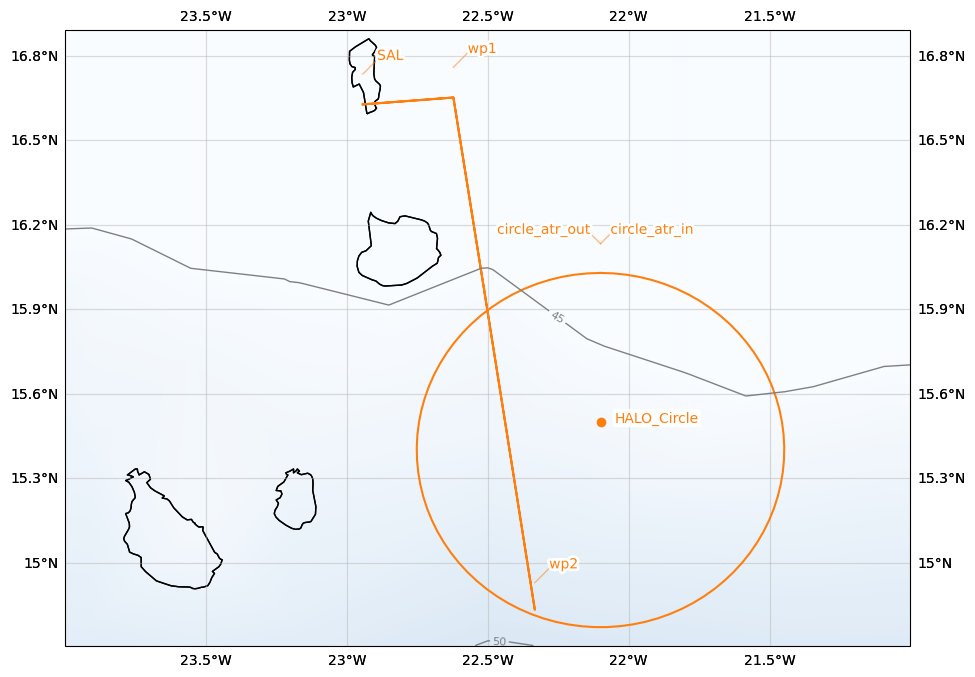
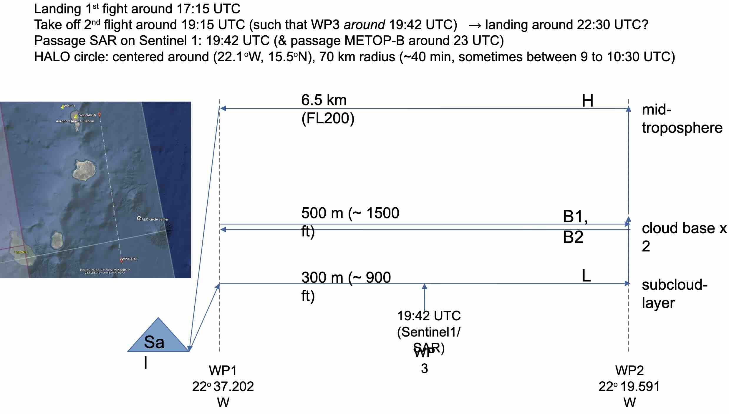
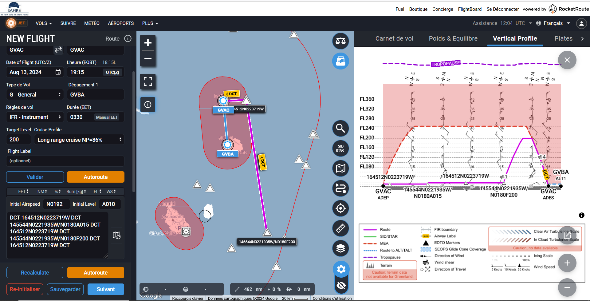
  • The flight is planned to take off at 2024-08-13 19:15:00+00:00 UTC and land at 2024-08-13 22:45:00+00:00 UTC.

  • The HALO circle around the ATR-transects will be of radius 70 km centered at 15.5 N, 22.1 W.

  • flight track designed for coordination with SAR on Sentinel-1 at 19:42 UTC (to study coherent structures near the ocean surface)

  • opportunity to sample the Northern edge of the ITCZ

  • nighttime conditions (better range for Raman lidar)

  • not too far from METOP-B (23 UTC)

Hide code cell source
from orcestra.flightplan import sal, bco, LatLon, IntoCircle, path_preview, plot_cwv
from datetime import datetime
import intake

cat = intake.open_catalog("https://tcodata.mpimet.mpg.de/internal.yaml")

date_time = datetime(2024, 8, 6, 12, 0, 0)
date_time_str = date_time.strftime('%Y-%m-%d')
flight_time = datetime(2024, 8, 13, 12, 0, 0)

radius = 70e3 # units: km
circle_atr = LatLon(lat=15.5, lon=-22.1, label="circle_atr")
halo_circle = IntoCircle(circle_atr, radius, 360)

airport = sal
wp1 = LatLon(lat=16.759083, lon=-22.622278, label='wp1')
wp2 = LatLon(lat=14.929167, lon=-22.333083, label='wp2')


path = [airport, wp1, wp2, wp1, airport]

ds = cat.HIFS(refdate=date_time_str, reftime=date_time.hour).to_dask()
cwv_flight_time = ds["tcwv"].sel(time=flight_time, method = "nearest")

ax = path_preview(path)
path_preview([circle_atr.course(0, radius), halo_circle], ax=ax)  # HACK: Add HALO circle
ax.scatter(circle_atr.lon, circle_atr.lat, color="tab:orange")
ax.text(circle_atr.lon+0.05, circle_atr.lat, color="tab:orange", s='HALO_Circle', bbox=dict(facecolor='white',edgecolor='white', boxstyle='round,pad=0.1'))
ax.set_extent([-24, -21, 14.8, 17])

plot_cwv(cwv_flight_time)
../_images/ecf10d2e5de159c79659bd7a97e9c769b325807ccd9b3c8934869d90c3fdaea7.png

Flight Levels

  • SAFIRE Flight Plan submitted to Air Traffic Control (ATC)

Page 1

Hide code cell source
import pandas as pd
from dataclasses import asdict

pd.DataFrame.from_records(map(asdict, path+[circle_atr])).set_index("label")
lat lon fl time note
label
SAL 16.734488 -22.943974 0.0 None None
wp1 16.759083 -22.622278 NaN None None
wp2 14.929167 -22.333083 NaN None None
wp1 16.759083 -22.622278 NaN None None
SAL 16.734488 -22.943974 0.0 None None
circle_atr 15.500000 -22.100000 NaN None None

Crew#

Job

Name

Pilot

Guillaume Seurat

Pilot

Jean-François Bourdinot

Mechanics

Thierry André

Expé Principal

Clément Bezier

Expé

Gilles Vergez

PI

Sandrine Bony

LNG

Kevin Huet

aWALI

Patrick Chazette

Microphys 1

Pierre Coutris

Microphys 2

Thierry Latchimy

RASTA

Sophie Bounissou

BASTA

Jérémie Lagarrigue