

Flight plan - HALO-20240924a#
ec_under ec_track c_west c_east c_pirouetteCrew#
Job |
Name |
|---|---|
PI |
Anna Weber |
WALES |
Sabrina Zechlau |
HAMP |
Luca Schmidt |
Dropsondes |
Marius Winkler |
Smart/VELOX |
Kevin Wolf |
SpecMACS |
Tobias Kölling |
Flight Documentation |
Rene Redler |
Ground contact |
Tobias Zinner, Sebastian Ortega |
Flight plan#
from datetime import datetime
import orcestra.sat
from orcestra.flightplan import tbpb, bco, point_on_track, LatLon, IntoCircle, FlightPlan

# Some fixed coordinates

lon_min, lon_max, lat_min, lat_max = -65, -5, -5, 25

airport = tbpb

radius = 72e3*1.852

# Define dates for flight

flight_time   = datetime(2024, 9, 24, 12, 0, 0)
flight_index = f"HALO-{flight_time.strftime('%Y%m%d')}a"

# Load satellite tracks

ec_fcst_time  = "2024-09-24"
ec_track = orcestra.sat.SattrackLoader("EARTHCARE", ec_fcst_time, kind="PRE",roi="BARBADOS") \
    .get_track_for_day(f"{flight_time:%Y-%m-%d}")\
    .sel(time=slice(f"{flight_time:%Y-%m-%d} 14:00", None))

# Use PACE_loader once only

pace_track = orcestra.sat.pace_track_loader() \
    .get_track_for_day(f"{flight_time:%Y-%m-%d}")

pace_track = pace_track.where(
    (pace_track.lat >lat_min)&
    (pace_track.lat <lat_max)&
    (pace_track.lon >-60)&
    (pace_track.lon <-30),
    drop = True) \
    .sel(time=slice(f"{flight_time:%Y-%m-%d} 11:00", f"{flight_time:%Y-%m-%d} 21:00"))
Flight index: HALO-20240924a
Take-off: 15:41 UTC
Landing:  21:27 UTC

Duration: 5:46:12.073628
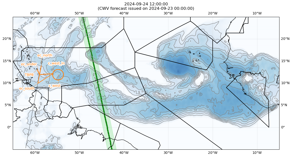

Detailed Overview:
              TBPB         N13 04.48, W059 29.55, FL000, 15:41:44 UTC,
to            ec_under     N12 00.00, W058 58.56, FL390, 15:52:59 UTC,
to            c_west_in    N12 12.00, W056 00.00, FL410, 16:16:12 UTC,
circle around c_west       N11 58.23, W054 47.86, FL410, 16:16:12 UTC - 17:15:46 UTC, radius: 72 nm, 360° CCW, enter from west
to            ec_south     N10 00.00, W059 21.47, FL430, 17:46:55 UTC,
to            ec_under     N12 00.00, W058 58.56, FL430, 18:02:47 UTC, meet EarthCARE
to            ec_north     N14 00.00, W058 35.42, FL430, 18:18:39 UTC,
to            ec_under     N12 00.00, W058 58.56, FL450, 18:34:27 UTC,
to            c_west_in    N12 12.00, W056 00.00, FL450, 18:57:09 UTC,
circle around c_west       N11 58.23, W054 47.86, FL450, 18:57:09 UTC - 19:55:42 UTC, radius: 72 nm, 360° CCW, enter from west
circle around c_west       N11 58.23, W054 47.86, FL450, 19:55:42 UTC - 20:54:14 UTC, radius: 72 nm, 360° CCW, enter from west
to            ec_under     N12 00.00, W058 58.56, FL450, 21:16:56 UTC,
to            TBPB         N13 04.48, W059 29.55, FL000, 21:27:56 UTC,